The wall display your hangar has been missing.
Live sectional charts, real ADS-B traffic, METARs, and hazard overlays — always on, always current, on a dedicated screen nobody has to babysit.
Now taking pre-orders · Ships early November
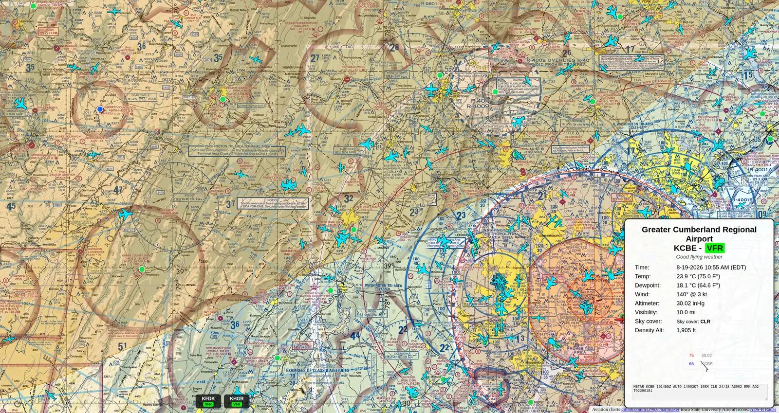
Everything a pilot checks before walking to the ramp.
Not a weather app squinting on a phone — a purpose-built display designed to be read from across the room.
Real ADS-B traffic, not a stock photo of a radar screen.
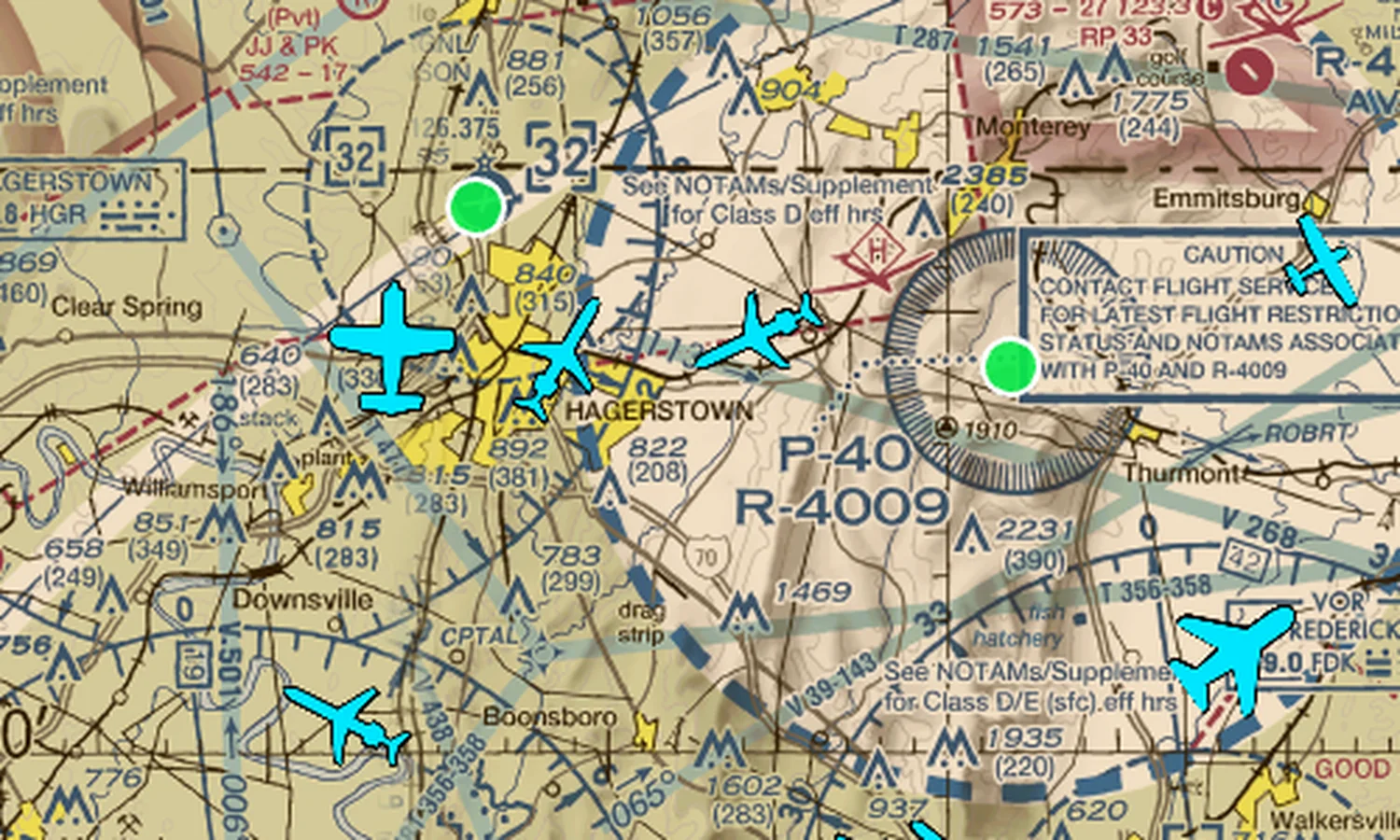
Aircraft render as actual type icons — not generic dots — scaled and outlined to stay readable on a TV across a lounge. Military traffic highlights in red; your own fleet highlights in magenta, so students learn to spot your aircraft on sight.
- Type-accurate icons for GA singles, twins, jets, rotorcraft
- Fleet & military highlighting, tuned for high-contrast visibility
- Built on the same sectional base map pilots already read
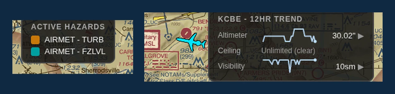
Flight category, hazards, and trend — at a glance, not a tap.
Your home airport's current conditions sit in a always-visible popup with flight category coloring. Active SIGMETs and AIRMETs (icing, turbulence, IFR, freezing level) get their own color-coded legend, and lightning strikes render live on the map.
- 12-hour trend sparklines for altimeter, ceiling, and visibility
- Winds aloft, sunrise/sunset countdown, local + Zulu clocks
- Every overlay toggles independently from a simple admin page
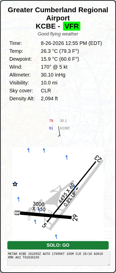
Your home field — diagram, live wind, and a student-solo call.
The always-on home card pairs the current METAR with your airport's real runway diagram and live wind arrows drifting across it — so anyone in the room can see at a glance how the wind lies on each runway. Switch on student-solo minimums and it adds a plain-language GO / NO-GO badge against your own limits.
- Real airport diagram with live wind arrows across every runway
- Student-solo GO / NO-GO against your own wind, crosswind, ceiling & visibility limits
- Favored runway and crosswind component computed from the live METAR
- Admin-gated and off by default — turn on only what your school wants
Every layer is optional. Turn on what matters at your field.
Nobody needs all of this running at once. Each overlay below toggles independently from /admin — no reboot, no re-provisioning, just a checkbox.
Fleet highlighting
List up to 50 of your own tail numbers and they render in magenta — instantly obvious against every other aircraft on screen.
Favorite airports
Pin up to 6 other fields — a practice area, a common cross-country stop — to a strip along the bottom with live flight category.
Airport diagram & wind
Your field's runway layout with live wind arrows flowing across it, so the wind on every runway is obvious at a glance.
Student-solo minimums
A GO / NO-GO badge that checks the current METAR against your own wind, crosswind, ceiling, and visibility limits for student solos.
Live ADS-B traffic
Type-accurate aircraft icons, scaled and outlined to stay readable across a room.
Military highlighting
Government/military-registered aircraft render in red automatically — no configuration needed.
Live NEXRAD radar
High-resolution weather radar mosaic, layered under everything else.
Lightning strikes
Recent strikes plot live on the map and fade out as they age off.
SIGMETs
Convective activity, severe turbulence, and icing — color-coded on the map with a legend.
AIRMETs
IFR conditions, turbulence, icing, freezing level, and mountain obscuration, each their own color.
TFRs
Active Temporary Flight Restrictions outlined right on the sectional as they're issued.
Home airspace boundary
Your field's own Class B/C/D/E outline, drawn directly on the chart.
12-hour weather trend
Sparklines for altimeter, ceiling, and visibility, so a shift in weather is obvious before it's read.
Winds aloft
Forecast winds and temperatures at 3,000 through 12,000 ft from the nearest station.
Active NOTAMs
Live NOTAMs for your home airport scroll in a panel — runway closures, TFRs, fuel outages, NAVAID status. Zero NOTAMs shows a clear-green confirmation.
Storm motion arrows
NEXRAD storm-cell tracking arrows show where cells are headed, so a line of storms building off-screen doesn't catch anyone off-guard.
Night dimming
Schedule automatic screen dimming for overnight hours — keeps the lounge comfortable without anyone touching a remote.
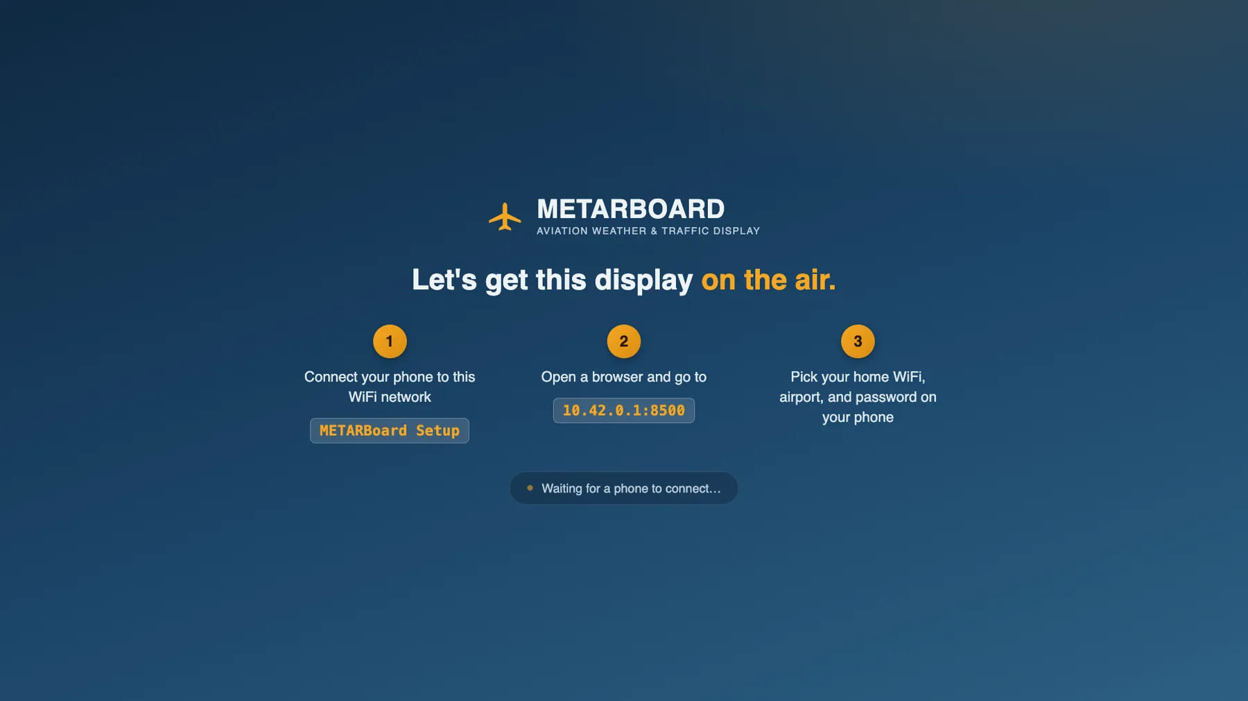
No keyboard. No mouse. No IT ticket.
Plug it into power and a screen. Everything else happens from a phone.
Connect your phone
The display broadcasts its own open WiFi network the first time it boots — no password to look up.
Open one page
Your phone gets a simple wizard. The TV shows plain instructions the whole time, so nobody's guessing.
Pick WiFi & airport
Choose your network, enter your home airport, set an admin password. The display reloads itself — done.
Appliance-grade, on purpose.
This is a display, not a computer someone has to maintain. It's built to recover from problems on its own.
Updates itself
New features and fixes ship automatically. Every update is verified before it's installed, and rolls back on its own if something's wrong.
Self-healing
A watchdog keeps the display honest — if anything on screen ever gets stuck, it recovers on its own, with nobody touching it.
Boots straight to the map
No desktop, no login screen, no taskbar. Power goes out, power comes back — the display is right back where it left off.
Before you ask — a few answers.
What does METARBoard show?
A live sectional chart with real ADS-B traffic, your home airport's current conditions and flight category, active SIGMETs and AIRMETs, lightning strikes, a 12-hour weather trend, winds aloft, sunrise/sunset — and a live NOTAM panel showing active notices for your home airport — all on one always-on display.
Is METARBoard safe to use for flight planning?
No. METARBoard is a situational-awareness display for ground use in briefing rooms, lounges, and ramps. It is not a certified avionics product and should never be used as a primary source for flight planning or in-flight decision making — always consult official briefings, NOTAMs, and ATC. (The NOTAM panel METARBoard shows is a convenience display only — treat it as a heads-up, not a substitute for a full official briefing.)
How is METARBoard set up?
There's no keyboard, mouse, or IT ticket involved. On first boot the display broadcasts its own open WiFi network; a phone connects to it, opens one page, picks a home WiFi network and airport, and the display reloads itself automatically.
Can METARBoard highlight my school's own aircraft?
Yes. Up to 50 tail numbers can be listed as fleet aircraft and they render in magenta on the map, distinct from every other aircraft, so students learn to spot your fleet on sight.
Does METARBoard need an internet connection to keep working?
It needs WiFi to pull live weather, traffic, and hazard data, but the sectional and terminal charts themselves are stored on the device, and the display self-updates and self-heals without any IT maintenance.
When will my pre-order ship?
METARBoard ships in early November. We'll email you at the address you provided when your unit goes out.
When am I charged for a pre-order?
The full $299 is charged at checkout as a one-time purchase, and Stripe emails you a receipt right away. There are no subscriptions or recurring fees.
Where does METARBoard ship?
We ship to the US and Canada, and shipping is free.
Where is METARBoard made?
METARBoard is designed, programmed, and built in Maryland, USA.
Pre-order
Get METARBoard in your space
Pre-orders are open now, and units ship early November. Order today and your METARBoard is on its way as soon as the first run is done.
One-time purchase · Free shipping to US & Canada · Ships early November
- ✓ Live sectional chart + ADS-B traffic
- ✓ METARs, TAFs, NOTAMs, radar, lightning
- ✓ SIGMETs, AIRMETs, TFRs, winds aloft
- ✓ Sets up from your phone — no IT needed
- ✓ Automatic software updates over Wi-Fi
Questions? sales@metarboard.io